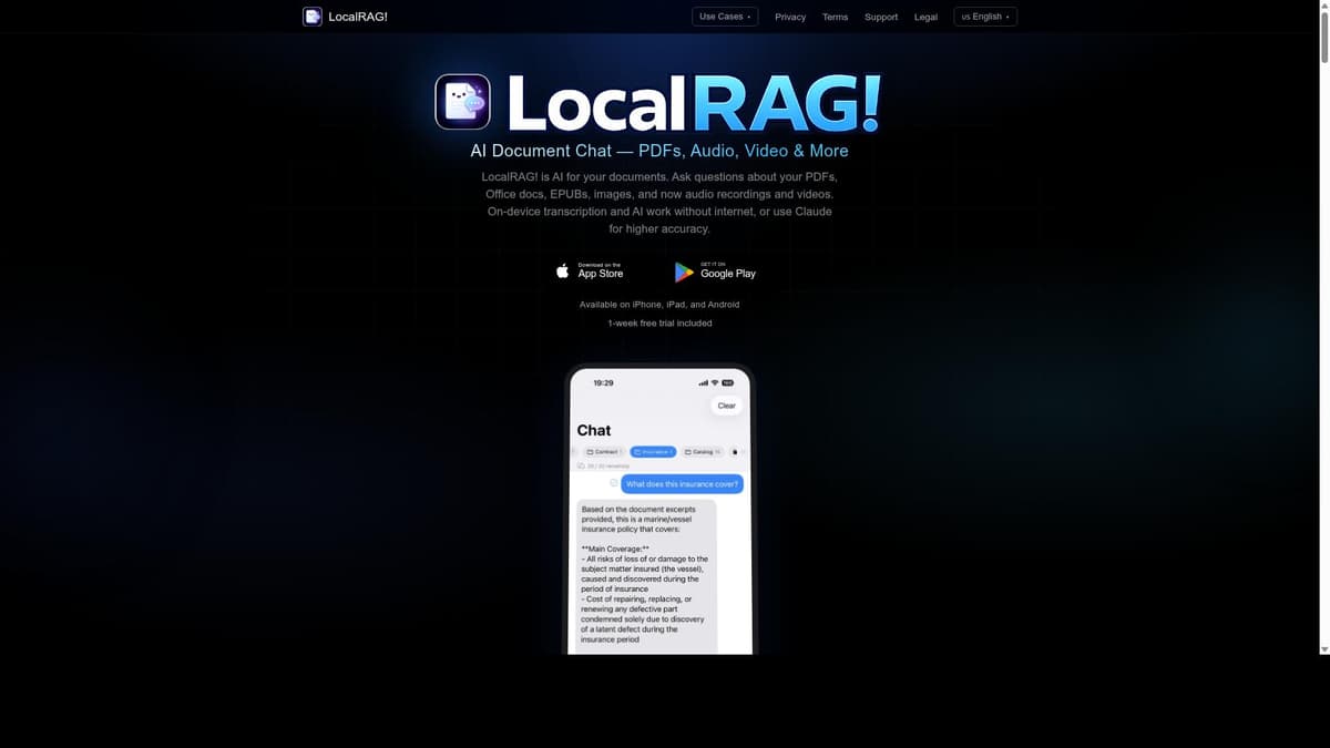
Earth Zoom Out AI

Description
Earth Zoom Out AI transforms any photo into a cinematic 6-second zoom out video revealing Earth from space, offering seamless transitions from street level to global views. Perfect for educators, marketers, and content creators seeking engaging geographic visualizations, it combines ease of use with powerful AI-driven effects—all for free.
Earth Zoom Out AI is an innovative tool designed to transform static images into dynamic, cinematic zoom out videos that reveal the Earth from space in just six seconds. Utilizing advanced AI technology, it enables users to create visually stunning content that seamlessly transitions from a detailed street-level view to a global perspective. The core purpose of Earth Zoom Out AI is to provide an engaging way to visualize geographical locations, making it ideal for storytelling, presentations, educational content, and creative projects that require a captivating spatial context. One of the standout features of Earth Zoom Out AI is its seamless zooming capability, which allows smooth transitions from a global view down to street-level details without any jarring jumps or interruptions. This creates a cinematic effect that enhances the viewer’s experience and provides a clear sense of scale and location. Additionally, the tool offers interactive geographical visualization, enabling users to explore maps in detail and customize their zoom out videos based on specific locations or images. The detailed map exploration feature ensures that every zoom out video is accurate and visually rich, capturing the essence of the place depicted in the original photo. The user-friendly interface of Earth Zoom Out AI makes it accessible to a wide range of users, from professional designers and marketers to educators and casual content creators. Its intuitive design means that even those without technical expertise can easily generate high-quality zoom out videos. This accessibility broadens its appeal and usability, making it a versatile tool for various applications such as travel blogs, real estate showcases, educational materials, and social media content. Earth Zoom Out AI is offered completely free of charge, which is a significant advantage for users looking to experiment with geographic visualization without financial commitment. This pricing model encourages widespread adoption and allows users to explore the tool’s capabilities fully before deciding if it fits their needs. Unlike many other AI-powered video creation tools that require subscriptions or pay-per-use fees, Earth Zoom Out AI provides a cost-effective solution with no hidden costs. When compared to alternative tools, Earth Zoom Out AI stands out due to its specific focus on zoom out videos that transition from street level to a global Earth view. While other platforms may offer general image generation or map visualization, few provide the seamless cinematic zoom effect combined with AI-powered transformation of photos into videos. This specialization gives it a unique niche in the market, particularly for users who want to create engaging geographic narratives or visual content that highlights spatial relationships. However, there are some considerations to keep in mind. The videos generated are limited to six seconds in length, which may not suit all use cases requiring longer or more detailed animations. Additionally, while the tool excels at zoom out effects, it may not support other types of video editing or customization beyond geographical zooming. Users seeking more comprehensive video production features might need to complement Earth Zoom Out AI with other software. Lastly, as a free tool, it may have limitations in terms of output resolution or advanced features that premium services offer. In summary, Earth Zoom Out AI is a powerful, easy-to-use tool that leverages AI to create captivating zoom out videos from any photo, revealing Earth from space in a matter of seconds. Its seamless zooming, interactive map exploration, and free pricing make it an excellent choice for educators, marketers, content creators, and anyone interested in geographic visualization. While it has some limitations in video length and editing scope, its unique focus and accessibility position it as a valuable resource for producing stunning Earth zoom out visual content.
Tool Features
- Seamless zooming from global to street level
- Interactive geographical visualization
- Detailed map exploration
- User-friendly interface
Frequently Asked Questions
What is Earth Zoom Out AI?
Earth Zoom Out AI is an AI-powered tool that creates cinematic zoom out videos from any photo, smoothly transitioning from street-level views to a global perspective of Earth in just six seconds.
How much does Earth Zoom Out AI cost?
Earth Zoom Out AI is completely free to use, allowing users to create zoom out videos without any subscription or payment.
Who is Earth Zoom Out AI best for?
It is ideal for educators, marketers, content creators, travel bloggers, real estate professionals, and anyone interested in creating engaging geographic visualizations or storytelling through dynamic zoom out videos.
What are the main features of Earth Zoom Out AI?
Key features include seamless zooming from global to street level, interactive geographical visualization, detailed map exploration, and a user-friendly interface that makes video creation accessible to all skill levels.
Does Earth Zoom Out AI offer a free trial?
Since Earth Zoom Out AI is free to use, there is no need for a free trial; users can access all features without any cost.
What integrations does Earth Zoom Out AI support?
Currently, Earth Zoom Out AI focuses on standalone functionality for creating zoom out videos and does not list specific integrations with other platforms or tools.
How does Earth Zoom Out AI work?
The tool uses AI to analyze any uploaded photo and generate a smooth, cinematic zoom out video that transitions from the photo’s location at street level to a view of Earth from space, leveraging detailed map data and geographical visualization techniques.
Sponsored Tools


Reviews
No reviews yet. Be the first to share your experience.